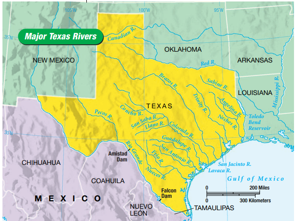
Rivers are important to Texas. Much of the Texas border is made up of three rivers. The Rio Grande separates Texas and Mexico and is the longest river in Texas. The Rio Grande begins in Colorado and flows about 1,900 miles southward through New Mexico before entering Texas near El Paso. Two large dams have been built on the Rio Grande in Texas: Amistad Dam and Falcon Dam. Water stored in reservoirs behind these dams is used to irrigate crops in Texas and Mexico.
The Sabine River separates Texas from Louisiana. The Sabine River
is much shorter than the Rio Grande, but it has also been dammed to
form Toledo Bend Reservoir. This reservoir provides water for drinking
as well as for industrial and agricultural uses.
The Red River separates Texas from Oklahoma. It begins in eastern
New Mexico and flows eastward to Arkansas. It originally flowed to the
Mississippi. Due to construction of a flood-control system, it now also
flows to the Gulf of Mexico. The Canadian River is the other important
river in the Panhandle. It begins in northern New Mexico and crosses
Texas to Oklahoma, where it joins the Arkansas River. The Canadian River
is the only major Texas river that does not flow into the Gulf of Mexico.
 |
| Major Texas Rivers. |
he Pecos River is an important tributary of the Rio Grande. It starts
in northern New Mexico and flows southward into Texas. The Pecos River
provides irrigation water for farms in New Mexico and Pecos, Texas.
Many Texas rivers flow into the Gulf of Mexico. These rivers include
the Neches, Trinity, San Jacinto, Brazos, Colorado, Guadalupe, San
Antonio, Nueces, and now the Red. Many important Texas cities are
located on these rivers. The locations, sizes, and characteristics of these
rivers influence the lives of residents of the Lone Star State.
No comments:
Post a Comment