 |
| Israel flag coloring picture |


Mountains - MCQs Test and Answers
01. The Himalayan Mountains are an example of:
a. Extraterrestrial impact.
b. Continent-ocean convergence.
c. A subduction zone.
d. Continent-continent convergence.
e. All the above
02. The sub-Himalayas or outermost Himalayas is also known as:
(a) Lesser Himalayas
(b) Great Snowy Himalayas
(c) The Siwaliks
(d) None of these
03. Which of the following states is considered a gateway to the Himalayas?
A) Peru.
B) Nepal.
C) Russia.
D) Kenya.
E) Switzerland.
04. Folded limestones that occur high in the Himalayas were originally deposited as sediments in a ________.
A) marine basin between India and Eurasia
B) Cenozoic fault basin between Africa and Arabia
C) deep ocean trench along the southern margin of India
D) late Paleozoic syncline north of the Tibetan Plateau
05. The process by which the Swiss Alps and many other non-volcanic mountain ranges are formed is known as what?
(a) Supraduction
(b) Melding
(c) Cascading
(d) Orogeny
06. Torres del Paine is a popular hiking destination in what South American mountainous region?
(a) Northern Andes
(b) Brazilian Highlands
(c) Roraima
(d) Patagonia
07. The height of Mount Everest is about;
(a) 8000 m
(b) 8848 m
(c) 9000 m
(d) None of these
08. The mountains which protect Pakistan from the cold winds of Central Asia:
(a) Himalayas
(b) Karakoram - Hindukush
(c) Kirthar
(d) None of these
09. The Valley and Ridge Province of the Appalachian Mountains is characterized by ________.
A) sedimentary strata folded in late Paleozoic time
B) deeply eroded, late Paleozoic, fault-block mountains and valleys
C) stratovolcanoes above a volcanic arc
D) crustal stretching as Africa and Eurasia migrated away from North America
10 - What mining region has the most varied mineral deposits of the world, with over 1,000 minerals? A) South Africa and Angola
B) the mountains of central Thailand
C) the Tibetan plateau
D) the Ural mountains
E) the Chilean Andes
11. The term ________ refers specifically to geologic mountain building.
A) orogneisses
B) orogeny
C) orthogeny
D) orthogonal
12. Topographically high-standing, mountainous areas generally ________.
A) are underlain by greater than average thicknesses of lower density, crustal rocks
B) subside rapidly to compensate for erosion
C) have thicker, higher density, mantle rocks beneath them at shallow depths
D) experience rapid erosion that thins the crust and causes the area to subside
13. Active mountain belts are most likely to be found ________.
A) along the margins of continents
B) along only the eastern margins of continents
C) scattered throughout continents
D) in the interior regions of continents
14. The ranges of the central and southern Rocky Mountains ________.
A) generally contain thick sections of highly folded, Paleozoic, marine strata
B) developed in response to a continent-continent collision
C) are uplifted blocks that typically have cores of Proterozoic igneous and metamorphic rocks
D) the Paleozoic and Mesozoic sedimentary rocks were elevated and compressed into tight folds; but the deeper, harder rocks of the continental crust were pulled apart by tensional stresses
15. A local dry wind occurring to the leeward side of the Rocky Mountains and often with high capacity to evaporate snow is
A. sea breeze B. land breeze
C. geostrophic wind
D. anticyclone
E. chinook wind
16. Which of the following best describes the bedrock in the Sierra Nevada Mountains in California?
a. basalt; dikes
b. gabbro; plutoliths
c. andesite; laccoliths
d. granite; batholiths
17. Tirich Mir is the highest peak of one of these mountain ranges:
(a) Hindu Kush
(b) Karakorum
(c) Koh i Safed
(d) None
18. The ________ are a geologically old mountain range folded and deformed during the Paleozoic.
A) Cascades in the northwestern United States
B) Rockies in the western United States
C) Appalachians in the eastern United States
D) Alps in Europe
19. If the coastlines of North America and Eurasia are matched up, the (1) ___________ mountains in North America match up with the (2) _________ in Eurasia, suggesting that they used to be one continuous mountain range.
A. (1) Appalachians (2) Caledonides
B. (1) Appalachians (2) Alps
C. (1) Rockies (2) Alps
D. (1) Rockies (2) Caledonides
E. (1) Cascades (2) Appalachians
20. Which one of the following statements concerning glaciers is not true?
A) Ice sheets are larger than ice caps.
B) Piedmont glaciers form on lowlands at the base of mountainous terrain.
C) The volume of water tied up in the Antarctic ice sheet is about the same as the total discharge of the Amazon River in one year.
D) Long, extended, alpine glaciers occupied valleys in most high, mountainous areas in the United States, Canada, and Europe at one or more times during the past two million years.
21. Which of the following explains why one side of a mountain usually has more precipitation than the other side?
a. Mountains force air to rise, and air cools and releases moisture as it rises.
b. The atmosphere gets denser as elevation increases.
c. Temperatures are higher on one side of a mountain than on the other.
d. The land on one side is more green and lush than the other.
22. Topographically high-standing, mountainous areas generally ________.
A) are underlain by greater than average thicknesses of lower density, crustal rocks
B) subside rapidly to compensate for erosion
C) have thicker, higher density, mantle rocks beneath them at shallow depths
D) experience rapid erosion that thins the crust and causes the area to subside
23. The ________ sides of mountains are often wet.
A) leeward
B) sunny
C) windward
D) steep
E) southern
24. Which of the following characteristics would suggest geologically recent, fault uplift of a desert mountain range?
A) flat, upland surfaces, steep slopes and small alluvial fans
B) extensive pediments and bajadas and small, deep playas
C) inselbergs, extensive pediments and flat valley floors
D) steep playas with extensive, bedrock alluvial fans and numerous sand dunes
25. The windward side of a mountain usually a. is
a desert.
b. has no precipitation.
c. is lush and green.
d. has warm, sinking air.
26. Which of the following best characterizes the tectonic development of fault-block mountains?
A) normal faults; crustal stretching and brittle failure of the upper crust
B) reverse faults; crustal stretching and brittle failure of the lower crust
C) normal faults; crustal shortening and plastic flowage of the upper crust
D) reverse faults; crustal shortening and plastic flowage of the lower crust
27. A boundary that uses physiological features like rivers or mountains is referred to as a(n)
A) geometric boundary.
B) subsequent boundary.
C) natural boundary.
D) permeable barrier.
E) ecumene.
28. In the Rocky Mountain region of the United States, north-facing slopes (downhill direction is toward the north) are typically more moist and heavily forested than south-facing slopes. Why?
A) North-facing slopes receive more sunlight in the summer; snow melts faster and more soil moisture is available for the trees.
B) South-facing slopes receive more moisture and sunlight; rock weathering is slower.
C) North-facing slopes receive about the same amount of precipitation as south-facing slopes; less moisture evaporates from north-facing slopes.
D) South-facing slopes receive less moisture, yet rock weathering is faster.
29. During the ________ Era, the westward-moving North American plate began to override the Pacific plate, eventually causing the tectonic activity that ultimately formed the mountains of western North America.
A) Precambrian
B) Paleozoic
C) Mesozoic
D) Cenozoic
E) none of the above
30. Which of the following states use mountains as a boundary?
A) Brazil and Peru.
B) Canada and the United States.
C) Iraq and Kuwait.
D) China and Russia.
E) Poland and Germany.
Answers:
01. D
02. C
03. B
04. A
05. D
06. D
07. B
08. A
09. A
10. D
11. B
12. A
13. A
14. C
15. E
16. D
17. A
18. C
19. A
20. D
21. A
22. A
23. C
24. A
25. C
26. A
27. C
28. B
29. C
30. A

Volcanoes - MCQs Test and Answers
01 - Which one of the following most accurately describes the volcanoes of the Hawaiian Islands?
A) stratovolcanoes associated with subduction and a convergent plate boundary
B) shield volcanoes fed by a long-lived hot spot below the Pacific lithospheric plate
C) shield volcanoes associated with a mid-Pacific ridge and spreading center
D) stratovolcanoes associated with a mid-Pacific transform fault
02 - Mount St. Helens and the other Cascade volcanoes are ________.
A) young, active stratovolcanoes built on a continental margin above a sinking slab of oceanic lithosphere
B) a row of young, active, shield volcanoes built as western North America moved over a hot spot deep in the mantle
C) old, deeply eroded stratovolcanoes built before the Pacific Ocean existed
D) old, deeply eroded, basaltic shield volcanoes built when western North America was over the presentday site of the Hawaiian hot spot
03 - Which of the following statements best describes the big Hawaiian volcanoes?
A) lie directly above a transform plate boundary that cuts deeply into the mantle
B) lie directly above an active subduction zone where the Pacific plate is sinking into the mantle
C) lie along the crest of the East Pacific Rise, a mid-ocean ridge or spreading center
D) are situated in the interior of a large, Pacific plate above a hot spot deep in the mantle
04 - Which of the following best describes Shiprock, a famous volcanic feature in New Mexico?
A) a very recently active, basaltic cinder cone
B) an extinct, highly symmetrical, composite volcanic cone
C) the eroded remains of a volcanic pipe and radiating dikes
D) an extinct, massive, rhyolitic shield volcano
05 - Which of the following is associated with deep mantle hot spots?
A) Vesuvius and the other volcanoes of Italy
B) the volcanoes of Hawaii and the Quaternary activity in Yellowstone National Park
C) the very young cinder cones scattered across the southwestern United States
D) Mt. St. Helens and other volcanoes of the Cascade Mountains
06 - Which region has the greatest concentration of currently active volcanoes?
A) the coastal plain of western Africa
B) European Russia and Siberia
C) the area surrounding the Red Sea
D) the circum-Pacific area
07 - Volcanic bombs originate ________.
A) as laser-guided, granite blocks launched from a supersonic jet
B) as blocks of volcanic rock ejected from an erupting volcanic crater
C) as erupted magma blobs that partly congeal before falling to the ground
D) as ash particles that join together in the eruptive plume and fall as cobble-sized objects
08 - ________ tend to increase the explosive potential of a magma body beneath a volcano.
A) High viscosity and dissolved gas
B) High viscosity; low dissolved gas content
C) Low silica content, low viscosity
D) Low viscosity; low dissolved gas content
09 - What volcanic events formed Crater Lake, OR? When did they take place?
A) A powerful explosion blew away the top of a stratovolcano; 10 million years ago.
B) The crater of a large, extinct cinder cone filled with water; 5 million years ago.
C) Landslides and volcanic mudflows dammed the Mazama River; 500 years ago.
D) Caldera collapse followed major ash and pyroclastic-flow eruptions; 6000 years ago.
10 - Kilauea is an example of a __________.
a. shield volcano
b. cinder cone
c. lava dome
d. volcanic neck
11 - ________ is a major dissolved volatile constituent in both magmas and volcanic gases?
A) Water
B) Carbon monoxide
C) Hydrogen chloride
D) Methane
12 - ____________ tend to increase the explosive potential of a magma body beneath a volcano.
a. High viscosity and dissolved gas
b. High viscosity; low dissolved gas content
c. Low silica content, low viscosity
d. Low viscosity; low dissolved gas content
13 - A ________ volcano is a very large, gently sloping mound composed mainly of basaltic lava flows.
A) composite
B) stratospheric
C) cinder cone
D) shield
14 - The Icelandic volcanoes are related to plate tectonics because ________.
A) they lie on a spreading center where two plates are converging
B) they lie on a subduction zone where two plates are converging
C) they lie on a spreading center where two plates are moving apart
D) they lie along a subduction zone where two plates are diverging
15 - In 1980, ________ was the first Cascade Range volcano to erupt since Mt. Lassen, California, in 1915-16.
A) Mt. Rainier
B) Mt. Shasta
C) Kilauea
D) Mt. St. Helens
16 - Which natural phenomenon occurs for many years after major explosive volcanic eruptions such as Tambora and Pinatubo?
A) heavy falls of volcanic ash within 100 km of the volcano
B) unusually warm weather in the tropics and subtropics
C) a worldwide rise in sea level of one to three centimeters
D) brilliantly colored sunrises and sunsets
17 - Which kind of eruptive activity is most likely to be highly explosive?
A) Lava flows from a large shield volcano on an oceanic island.
B) Fissure eruptions feeding lava to flood basalt accumulations.
C) Eruptions of big, continental margin, composite cones or stratovolcanoes.
D) Lava flows from a large cinder cone complex.
18 - Shield volcanoes are most likely to form in which plate tectonic setting?
(a) intraplate hot spot on continental crust
(b) continental rifts
(c) subduction zones
(d) intraplate hot spot on oceanic crust
(e) continent-continent collisions.
19 - Which one of the following is most likely to be associated both with impact craters and with volcanic calderas that originate by collapse?
A) outwardly radiating, fragmental, bright, surface streaks
B) sharp rims that rise well above the surrounding area far away from the edge of the depression
C) landslides and other mass wasting movements along the walls of the depression
D) sharp, central peaks that rise above the floor of the depression
20 - Which type of volcanic eruption is less likely to be a hazard to humans living in the area?
(a) Pyroclastic flows from a stratovolcanoe
(b) Basaltic eruption from a mid-plate hotspot
(c) rhyolitic eruption composite volcanoe located on a subduction zone
(d) Island arc volcanoes with a high percentage of dissolved gasses
(e) Continental hot-spot eruptions
21 - A ____________ stream pattern is developed only on growing mountains like volcanoes or where the land surface is tectonically doming upward.
a. radial
b. dendritic
c. boreal
d. trellis
22 - Silicic magma typically produces
A. spatter cones.
B. composite volcanoes.
C. cinder cones.
D. shield volcanoes.
E. fissure eruptions.
23 - Andesite volcanoes occur most frequently
A. along continental margins.
B. on stable platforms.
C. in linear chains of volcanic islands like Hawaii.
D. along continental rift zones.
E. along mid-oceanic ridges.
24 - The Hawaiian Islands
A. are a series of shield volcanoes
B. formed from a series of violent volcanic eruptions
C. lies atop the meeting place of two major tectonic plates
D. all of the above
25 - Which of the following is a possible consequence of the break-up of the Gondwanaland to form Africa?
A. its relatively high elevation with high interior plateaus and plains
B. the development of the Great Escarpment which separates the narrow coastal plain from the interior plateau, especially in southern Africa
C. the dominance of volcanoes and hotspots on the continent
D. its basin and dome topography
E. All of the above
26 - What caused the mudflows (1985) on the Nevado del Ruiz volcano?
A) Hot ash fell onto snow near the summit.
B) A crater lake was broken during an eruption.
C) Warm weather caused rapid melting of snow and ice near the summit.
D) all of the above
27 - A stratovolcanoe or composite volcano is composed of
(a) a large bowl-like depression.
(b) thick sticky lava flows.
(c) ash-flow tuffs.
(d) alternating thin layers of flow and pyroclastic deposits.
28 - Paricutin is an example of a __________.
a. shield volcano
b. cinder cone
c. lava dome
d. composite volcano
29 - Mount Pelée on Martinique is an example of a __________.
a. shield volcano
b. cinder cone
c. lava dome
d. composite volcano
30 - What is the largest, known volcano in the Solar System?
A) Mauna Loa, Hawaii, Earth
B) Mount Olympus, Greece, Earth
C) Mauna Kea, southern hemisphere, Mars
D) Olympus Mons, Mars
31 - Volcanic glass is produced by
A. slow cooling.
B. rapid cooling.
C. any two different rates of cooling.
D. rapid cooling followed by slow cooling.
E. slow cooling followed by rapid cooling.
32 - Which kind of volcanism is typical of mid-oceanic ridge systems?
A) explosive; composite cones
B) submarine; basaltic lava flows
C) fissure eruptions; flood basalts fields
D) explosive; rhyolitic, pyroclastic flows
33 - An example of intraplate volcanism is:
(a) Aleutian Islands
(b) Hawaii
(c) Mt. St. Helens
(d) None of these
34 - Volcanism along a continental arc is dominated by the eruption of ________.
A) basaltic lava flows
B) andesitic lavas and pyroclastic materials
C) rhyolitic pyroclastic materials and lavas
D) all of the above
35 - Volcanic arcs are primarily composed of
a. granite and phyllite.
b. gabbro and gneiss. c. basalt and pyroxenite.
d. andesite and diorite.
e. All of the above
36 - Which of the following best describes Shiprock, a famous volcanic feature in New Mexico?
a. a very recently active, basaltic cinder cone
b. an extinct, highly symmetrical, composite volcanic cone
c. the eroded remains of a volcanic pipe and radiating dikes
d. an extinct, massive, rhyolitic shield volcano
37 - A volcano that has been sleeping for a while but may still erupt is called a(n) __________ volcano. a. active
b. dormant
c. extinct
38 - Volcanic chains are formed as a lithosphere plate moves over a:
(a) Volcanic front
(b) Mantle plume
(c) Arc trench gap
(d) None of these
Answers:
01- B
02 - A
03 - D
04 - C
05 - B
06 - D
07 - C
08 - A
09 - D
10 - A
11 - A
12 - A
13 - D
14 - C
15 - D
16 - D
17 - C
18 - D
19 - C
20 - B
21 - A
22 - B
23 - A
24 - A
25 - E
26 - A
27 - D
28 - B
29 - D
30 - D
31 - B
32 - B
33 - B
34 - B
35 - D
36 - C
37 - B
38 - B
31 - B
32 - B
33 - B
34 - B
35 - D
36 - C
37 - B
38 - B
20 Questions and Answers About Volcanoes
01. Composite volcanic cones are also known as ________.
02. ________, in the north Atlantic Ocean, is a volcanic island formed over a hot spot on a divergent plate boundary.
03. The largest shield volcano yet observed in the solar system is located on ________.
04. A relatively small, summit depression on a volcano, marking a former eruptive vent, is a ________.
05. Which kind of volcano is closely associated with convergent plate boundaries and subduction zones?
06. A(n) ________ is a volcanic mountain built up from the seafloor that never reached the sea surface.
07. What is another name for volcanic mudflows, like those formed during the Mount St. Helens and Nevado del Ruiz eruptions?
08. Large, volcanic depressions formed by subsidence and collapse are known as ________.
09. Another term for a volcanic mudflow is a ________.
10. What term describes fragmental volcanic material?
11. Strato or composite volcanoes are typical of _________________ _______.
12. Mt Shasta and Lassen formed in what kind of tectonic setting?
13. ________ is a dangerous, fast moving, hot, turbulent cloud of volcanic gases and fine-sized, pyroclastic particles.
14. An increase in ___________activity in western India, along with a drop in sea level, and a meteorite impact led to extinctions of many of the ________________, ~65 m.y. ago.
15. The hot molten material erupted from a volcano is called:
(a) Lava
(b) Magma
(c) Pyro-clast
(d) None of these
16. Volcanoes can occur __________.
a. on land only
b. only in the ocean
c. both on land and in the ocean
17. The volcanoes and deep valleys of east Africa are related to a ________.
A) continental rift along which parts of the African continent are beginning to slowly separate
B) fault allowing Arabia to slip westward past east Africa and penetrate into Turkey
C) transform fault aligned with the Red Sea carrying the Arabian and African blocks in opposite directions
D) continental collision zone between Africa and the Zagros Mountains along the southern margin of Eurasia
18. Kilauea and Mauna Loa are ________.
A) explosive, rhyolitic volcanoes
B) andesitic stratovolcanoes
C) basaltic shield volcanoes
D) small, basaltic cinder cones
19. A volcano that is currently erupting is called a(n) __________ volcano.
a. active
b. dormant
c. extinct
20. What is the largest, known volcano in the Solar System?
a. Mauna Loa, Hawaii, Earth
b. Mount Olympus, Greece, Earth
c. Mauna Kea, southern hemisphere, Mars
d. Olympus Mons, Mars
Answers:
01. stratovolcanoes.
02. Iceland.
03. crater.
04. crater.
05. composite or stratovolcano.
06. seamount.
07. lahars.
08. calderas.
09. lahar.
10. pyroclastic.
11. volcanic arcs
12. volcanic arc setting associated with a convergent margin.
13. nueé ardente.
14. volcanic, dinosaurs.
15. A
16. C
17. A
18. C
19. A
20. D

What causes earthquakes?
The short answer is that earthquakes are caused by faulting, a sudden lateral or vertical movement of rock along a rupture (break) surface.
Here's the longer answer: The surface of the Earth is in continuous slow motion. This is plate tectonics--the motion of immense rigid plates at the surface of the Earth in response to flow of rock within the Earth. The plates cover the entire surface of the globe.

Since they are all moving they rub against each other in some places (like the San Andreas Fault in California), sink beneath each other in others (like the Peru-Chile Trench along the western border of South America), or spread apart from each other (like the Mid-Atlantic Ridge). At such places the motion isn't smooth--the plates are stuck together at the edges but the rest of each plate is continuing to move, so the rocks along the edges are distorted (what we call "strain").
As the motion continues, the strain builds up to the point where the rock cannot withstand any more bending. With a lurch, the rock breaks and the two sides move. An earthquake is the shaking that radiates out from the breaking rock.
People have known about earthquakes for thousands of years, of course, but they didn't know what caused them. In particular, people believed that the breaks in the Earth's surface--faults--which appear after earthquakes, were caused *by* the earthquakes rather than the cause *of* them. It was Bunjiro Koto, a geologist in Japan studying a 60-mile long fault whose two sides shifted about 15 feet in the great Japanese earthquake of 1871, who first suggested that earthquakes were caused by faults. Henry Reid, studying the great San Francisco earthquake of 1906, took the idea further.
He said that an earthquake is the huge amount of energy released when accumulated strain causes a fault to rupture. He explained that rock twisted further and further out of shape by continuing forces over the centuries eventually yields in a wrenching snap as the two sides of the fault slip to a new position to relieve the strain. This is the idea of "elastic rebound" which is now central to all studies of fault rupture.
Source: Dr. Gerard Fryer / University of Hawaii.

Sedimentary Rocks - MCQs Test and Answers
01. ________ rocks always originate at the surface of the solid Earth.
A) Secondary
B) Igneous
C) Metamorphic
D) Sedimentary
02. Which of the following best describes the fundamental concept of superposition?
A) Strata with fossils are generally deposited on strata with no fossils.
B) Older strata generally are deposited on younger strata without intervening, intermediate age strata.
C) Older fossils in younger strata indicate a locally inverted geologic time scale.
D) Any sedimentary deposit accumulates on older rock or sediment layers.
03. ________ in layered sedimentary rocks are evidence for horizontal compression and shortening. A) Normal faults
B) Strike-slip faults
C) Horsts and grabens
D) Tight folds
04. The ________ of the Appalachian orogen consists of North American, continental shelf strata deposited prior to the late Paleozoic collision with Africa.
A) metamorphic and igneous rocks of the Blue Ridge
B) igneous and regionally metamorphosed rocks of the Piedmont
C) Cretaceous and Tertiary strata of the coastal plain and continental shelf
D) folded, sedimentary rocks of the Valley and Ridge Province
05. ________ basins are characterized by thick sequences of relatively undeformed sedimentary rocks.
A) Forearc
B) Backarc
C) Transform fault
D) Evaporite
06. A immature sedimentary rock is characterized by:
(a) angular grains
(b) a variety of minerals
(c) mixed grain size
(d) poorly sorted texture
(e) all of these
07. Which one of the following statements is not correct?
A. Metamorphic rocks may melt to magma.
B. Sedimentary rocks may weather to igneous rocks.
C. Magmas crystallize to form igneous rocks.
D. Igneous rocks can undergo metamorphism.
08. Geologists study sedimentary rocks because
a. They provide a record of Earth’s history.
b. They are sources of fossil fuels.
c. They may contain important mineral resources.
d. They may contain fossils, providing a history of life including human evolution
e. All of the above
09. Organisms play a significant role in the origin of _____ sedimentary rock.
a. Clastic
b. Biogenic
c. Chemical
d. Lithologic
e. None of the above
10. Biochemical sedimentary rocks may form by
a. Evaporation
b. Erosion
c. Metamorphism
d. Floods
e. None of the above
11. Sedimentary rocks are classified by
a. Mineralogy and fossils.
b. Cementation and compaction.
c. Environment of precipitation and environment of deposition.
d. Composition and texture.
e. All the above
12. The angularity of the edges and corners of grains in a sedimentary rock is referred to as
a. roughness
b. smoothness
c. rounding
d. abruptness
e. none of the above
13. The process of reducing pore space by depositing younger sediments on top of older material is referred to as
a. dilation
b. reduction
c. contraction
d. compaction
e. none of the above
14. A common mineral found in carbonate sedimentary rocks is
a. quartz
b. K-feldspar
c. plagioclase
d. calcite
e. gypsum
15. An example of a siliceous chemical sedimentary rock is
a. quartz siltstone
b. quartz sandstone
c. quartz mudstone
d. chert
e. siliceous argillite
16. Alluvial fans develop at the base of
a. the continental shelf
b. the continental slope
c. mountain fronts
d. fault scarp
e. none of the above
17. A stable platform is a region characterized by
A. No vertical crustal movement until recent times
B. A complete lack of deformed rocks at any depth
C. Numerous folds and faults
D. Horizontal sedimentary rocks overlying the crystalline Basement Complex rocks
E. Extensive exposures of igneous and metamorphic rocks
18. The material from which chemically-precipitated sedimentary rocks are made is transported to the place of deposition
A. by wind.
B. as silt.
C. as sediment particles.
D. as clastic particles.
E. in solution.
19. Fossil remains of ancient organisms are most commonly found in
A. basalt.
B. granite.
C. metamorphic rocks.
D. gypsum.
E. sedimentary rocks
20. Which of the following particles in sedimentary rocks is smallest in size?
A. Silt
B. Clay
C. Gravel
D. Sand
Answers:
01. D
02. D
03. D
04. D
05. A
06. E
07. B
08. E
09. B
10. A
11. D
12. C
13. D
14. D
15. D
16. C
17. D
18. E
19. E
20. B


Principal Types of Volcanoes
Geologists generally group volcanoes into four main kinds--cinder cones, composite volcanoes, shield volcanoes, and lava domes.
Cinder cones
Cinder cones are the simplest type of volcano. They are built from particles and blobs of congealed lava ejected from a single vent. As the gas-charged lava is blown violently into the air, it breaks into small fragments that solidify and fall as cinders around the vent to form a circular or oval cone. Most cinder cones have a bowl-shaped crater at the summit and rarely rise more than a thousand feet or so above their surroundings. Cinder cones are numerous in western North America as well as throughout other volcanic terrains of the world.
 |
| Schematic representation of the internal structure of a typical cinder cone. |
In 1943 a cinder cone started growing on a farm near the village of Parícutin in Mexico. Explosive eruptions caused by gas rapidly expanding and escaping from molten lava formed cinders that fell back around the vent, building up the cone to a height of 1,200 feet. The last explosive eruption left a funnel-shaped crater at the top of the cone. After the excess gases had largely dissipated, the molten rock quietly poured out on the surrounding surface of the cone and moved downslope as lava flows. This order of events--eruption, formation of cone and crater, lava flow--is a common sequence in the formation of cinder cones.
During 9 years of activity, Parícutin built a prominent cone, covered about 100 square miles with ashes, and destroyed the town of San Juan. Geologists from many parts of the world studied Parícutin during its lifetime and learned a great deal about volcanism, its products, and the modification of a volcanic landform by erosion.
 |
| Parícutin Volcano, Mexico, is a cinder cone rising approximately 1,200 feet above the surrounding plain. |
Composite volcanoes
Some of the Earth's grandest mountains are composite volcanoes--sometimes called stratovolcanoes. They are typically steep-sided, symmetrical cones of large dimension built of alternating layers of lava flows, volcanic ash, cinders, blocks, and bombs and may rise as much as 8,000 feet above their bases. Some of the most conspicuous and beautiful mountains in the world are composite volcanoes, including Mount Fuji in Japan, Mount Cotopaxi in Ecuador, Mount Shasta in California, Mount Hood in Oregon, and Mount St. Helens and Mount Rainier in Washington.
Most composite volcanoes have a crater at the summit which contains a central vent or a clustered group of vents. Lavas either flow through breaks in the crater wall or issue from fissures on the flanks of the cone. Lava, solidified within the fissures, forms dikes that act as ribs which greatly strengthen the cone.
The essential feature of a composite volcano is a conduit system through which magma from a reservoir deep in the Earth's crust rises to the surface. The volcano is built up by the accumulation of material erupted through the conduit and increases in size as lava, cinders, ash, etc., are added to its slopes.
 |
| Schematic representation of the internal structue of a typical composite volcano |
When a composite volcano becomes dormant, erosion begins to destroy the cone. As the cone is stripped away, the hardened magma filling the conduit (the volcanic plug) and fissures (the dikes) becomes exposed, and it too is slowly reduced by erosion. Finally, all that remains is the plug and dike complex projecting above the land surface--a telltale remnant of the vanished volcano.
 |
| Shishaldin Volcano, an imposing composite cone, towers 9,372 feet above sea level in the Aleutian Islands, Alaska. |
An interesting variation of a composite volcano can be seen at Crater Lake in Oregon. From what geologists can interpret of its past, a high volcano--called Mount Mazama- probably similar in appearance to present-day Mount Rainier was once located at this spot. Following a series of tremendous explosions about 6,800 years ago, the volcano lost its top. Enormous volumes of volcanic ash and dust were expelled and swept down the slopes as ash flows and avalanches. These large-volume explosions rapidly drained the lava beneath the mountain and weakened the upper part. The top then collapsed to form a large depression, which later filled with water and is now completely occupied by beautiful Crater Lake. A last gasp of eruptions produced a small cinder cone, which rises above the water surface as Wizard Island near the rim of the lake. Depressions such as Crater Lake, formed by collapse of volcanoes, are known as calderas. They are usually large, steep-walled, basin-shaped depressions formed by the collapse of a large area over, and around, a volcanic vent or vents. Calderas range in form and size from roughly circular depressions 1 to 15 miles in diameter to huge elongated depressions as much as 60 miles long.
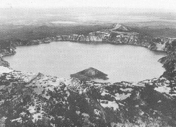 |
| Crater Lake, Oregon; Wizard Island, a cinder cone, rises above the lake surface. |
The Evolution of a Composite Volcano

A. Magma, rising upward through a conduit, erupts at the Earth's surface to form a volcanic cone. Lava flows spread over the surrounding area.
B. As volcanic activity continues, perhaps over spans of hundreds of years, the cone is built to a great height and lava flows form an extensive plateau around its base. During this period, streams enlarge and deepend their valleys.
C. When volcanic activity ceases, erosion starts to destroy the cone. After thousands of years, the great cone is stripped away to expose the hardened "volcanic plug" in the conduit. During this period of inactivity, streams broaden their valleys and dissect the lava plateau to form isolated lava-capped mesas.
D. Continued erosion removes all traces of the cone and the land is worn down to a surface of low relief. All that remains is a projecting plug or "volcanic neck," a small lava-capped mesa, and vestiges of the once lofty volcano and its surrounding lava plateau.
Shield volcanoes
 |
| The internal structure of a typical shield. |
Shield volcanoes, the third type of volcano, are built almost entirely of fluid lava flows. Flow after flow pours out in all directions from a central summit vent, or group of vents, building a broad, gently sloping cone of flat, domical shape, with a profile much like that of a warrior's shield. They are built up slowly by the accretion of thousands of highly fluid lava flows called basalt lava that spread widely over great distances, and then cool as thin, gently dipping sheets. Lavas also commonly erupt from vents along fractures (rift zones) that develop on the flanks of the cone. Some of the largest volcanoes in the world are shield volcanoes. In northern California and Oregon, many shield volcanoes have diameters of 3 or 4 miles and heights of 1,500 to 2,000 feet. The Hawaiian Islands are composed of linear chains of these volcanoes including Kilauea and Mauna Loa on the island of Hawaii-- two of the world's most active volcanoes. The floor of the ocean is more than 15,000 feet deep at the bases of the islands. As Mauna Loa, the largest of the shield volcanoes (and also the world's largest active volcano), projects 13,677 feet above sea level, its top is over 28,000 feet above the deep ocean floor.
 |
| Mauna Loa Volcano, Hawaii, a giant among the active volcanoes of the world; snow-capped Mauna Kea Volcano in the distance. |
In some eruptions, basaltic lava pours out quietly from long fissures instead of central vents and floods the surrounding countryside with lava flow upon lava flow, forming broad plateaus. Lava plateaus of this type can be seen in Iceland, southeastern Washington, eastern Oregon, and southern Idaho. Along the Snake River in Idaho, and the Columbia River in Washington and Oregon, these lava flows are beautifully exposed and measure more than a mile in total thicknes.
Lava domes
 |
| Schematic representation of the internal structure of a typical volcanic dome. |
Volcanic or lava domes are formed by relatively small, bulbous masses of lava too viscous to flow any great distance; consequently, on extrusion, the lava piles over and around its vent. A dome grows largely by expansion from within. As it grows its outer surface cools and hardens, then shatters, spilling loose fragments down its sides. Some domes form craggy knobs or spines over the volcanic vent, whereas others form short, steep-sided lava flows known as "coulees." Volcanic domes commonly occur within the craters or on the flanks of large composite volcanoes. The nearly circular Novarupta Dome that formed during the 1912 eruption of Katmai Volcano, Alaska, measures 800 feet across and 200 feet high. The internal structure of this dome--defined by layering of lava fanning upward and outward from the center--indicates that it grew largely by expansion from within.
 |
| The Novarupta Dome formed during the 1912 eruption of Katma Volcano, Alaska. |
Mont Pelée in Martinique, Lesser Antilles, and Lassen Peak and Mono domes in California are examples of lava domes. An extremely destructive eruption accompanied the growth of a dome at Mont Pelée in 1902. The coastal town of St. Pierre, about 4 miles downslope to the south, was demolished and nearly 30,000 inhabitants were killed by an incandescent, high-velocity ash flow and associated hot gases and volcanic dust.
Only two men survived; one because he was in a poorly ventilated, dungeon-like jail cell and the other who somehow made his way safely through the burning city.
 |
| A sketch of the havoc wrought in St. Pierre Harbor on Martinique during the eruption of Mont Pelée in 1902. |
Source: USGS.


Subscribe to:
Posts (Atom)